2. Installation requirement for ECDIS 电子海图的安装要求(二)-外接设备要求
1) ECDIS should be connected to the ship’s position fixing system, to the gyro compass and to the speed and distance measuring device(log). For ships not fitted with a gyro compass ECDIS should be connected to a marine transmitting heading device
电子海图系统要求必须有船位系统/电罗经以及速度距离设备(计程仪), 对不配有电罗经的船舶需要有船首向发射装置,这个设备简单说是提供船舶真船首向的电子设备,它的船首向信息可以来源于定位系统的计算信息,也可以是磁罗经船首向修正后的信息
2)The ECDIS display may also be used for the display of radar, radar tracked target information, AIS, Echo Sounder and other appropriate data layers to assist in route monitoring.
电子海图系统也可以显示来自雷达,雷达物标,自动识别系统,测深仪和其他叠加数据从而协助航线监控。
3)ECDIS should not degrade the performance of any equipment providing sensor inputs. Nor should the connection of optional equipment degrade the performance of ECDIS below this standard
电子海图系统不能降级显示其他连接设备的信息数据,同样其他设备连接到电子海图系统也不影响电子海图系统应有的性能
As per current requirement only above mentioned 3 signal need to integrate into ECDIS, other signal not compulsory to be connected, of course in our fleet, the Navmaster model we used manufactured by PC Maritime是将雷达信号及物标、自动识别系统和测深仪连接到ECDIS的
按照目前的国际公约的要求电子海图系统只要求上边陈述的3种信号输入叠加,其他信号都不是强制的,当然我们公司配备的PC MARITIME生产的NAVMASTER 型号电子海图是有连接雷达OVERLAY 、雷达物标、自动识别系统和测深仪的信息
3. Voyage recording for ECDIS 电子海图的航行记录
1)ECDIS should store and be able to reproduce certain minimum elements required to reconstruct the navigation and verify the official database used during the previous 12 hours. The following data should be recorded at one minute intervals:
a.to ensure a record of own ship's past track: time, position, heading, and speed; and
b.to ensure a record of official data used: ENC source, edition, date, cell and update
电子海图系统应能保存并复制过去12小时内的航行的基本要素来重现过去的航行状态以及官方数据库,下述数据应至少每分钟记录并保存:
a.船舶航迹,时间,船位, 船首向和船速
b.航用图来源,版期,日期,航用图号以及更新状态
2)In addition, ECDIS should record the complete track for the entire voyage, with time marks at intervals not exceeding 4 hours.
另外,电子海图系统应能记录完整的本航次航迹,并有不超过4小时的时间标记
3)It should not be possible to manipulate or change the recorded information。
所记录的信息不应能被篡改
4)ECDIS should have a capability to preserve the record of the previous 12 hours and of the voyage track.
电子海图系统应有能力保存过去12小时的记录和航迹
In viewing of above requirement all officers should familiar with ECDIS playback function, and knowing how to recall last 12 hour track and track for current whole voyage, this operation may be requested by external inspector during inspection
鉴于以上要求,驾驶员要熟练掌握电子海图的回放功能操作, 并知道如何调出过去12小时的航迹以及本航次的航迹,这些操作很可能在外部检查中被检察官要求操作
二. ECDIS passage planning 电子海图航行计划
Trusted last PPT topic passage plan was read by all of you and understood well, so basically
the theory and procedures for preparing and implementing passage plan by ECDIS is same
with paper chart. So I will not explain again in this PPT
相信大家都读过我上篇主题是航行计划的PPT并都很好的理解了,基本上在电子海图上编制航行计划并执行航行计划的理论和程序基本和纸板海图一致(见4月份的passage plan公众号),在此不具体讲述

三. Key element of passage planning for ECDIS 电子海图航行计划关键要素的详解
1.ENC cells (航用图单元)
ECDIS 通过由一系ECDIS displays continuous coverage by making up of a series of indi
vidual ENC files known as “ENC cells”, each cell is less than 5MB in size, in most cases producers
allow you to licence ENC cells individually so that you can build the exact coverage that you require
列称为“ENC 单元”的单独 ENC 文件组成来保证全球海区的连续覆盖,每个单元的文件尺寸小于 5MB,在大多数情况下,生产商允许单独申请你所需要的ENC 单元许可,以便可以构建准确的所需要的海区覆盖范围
2. ENC cells naming rule(航用图单元命名原则)
ENC cells are named using a unique eight character identifier together with a three character file type extension
每个航用图单元使用8个字符外加3个扩展名字符组成
v如下图所示, 前2位字符CC代表海图发行商的代码,这个代码是根据S-62标准制定的,S-62把每一个IHO的成员国以及其他组织都给与一个代码, 比如印度发行的海图代码为IN, 英国GB,新加坡SG,中国CN,这个想必大家都熟悉

v 第3个字符P 代表这张海图的用途,如下图所示,1-6个数字分别代表不同比例尺的海图,见下图

vXXXXX这5个字符是各个水道测量局给自己发布的海图命名的名字,命名原则由各自水道测量局决定,有的水道测量局是以相应的纸板海图号来命名,有的事宜海图覆盖边界经纬度来命名,有的是以海图海图内的显著岸标名字组合命名,见下图
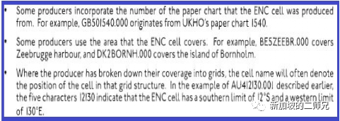
v最后3个扩展名字符是表明这张航用图更新的次数,001表明这张图有个一次更新,000则标识没有更新或把以前所有更新汇总重印REPRINT后扩展名从000开始
希望大家通过以上的解释对电子海图命名有个清晰的解读
3. ECDIS chart 1
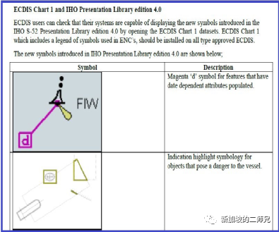
ECDIS users can check that their systems are capable of displaying the new symbols intro
duced in the IHO S-52 Presentation Library edition 4.0 by opening the ECDIS Chart 1 datasets. ECDIS Chart 1, which includes a legend of symbols used in ENC's, should be installed on all type approved ECDIS.
Master and officers should be familiar with opening ECDIS CHART 1 in own ship ECDIS and knowing how to verify if the legend displaying is complying with S-52 standard
电子海图使用者在核实本船系统是否能够根据国际水道测量局的S-52的显示图库4.0版本来显示图标,要使用ECDIS CHART 1,它包括了用于电子海图显示的所有图例,见左下图

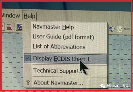
公司使用的电子海图系统NAVMATER 可以打开帮助菜单调取ECDIS CHART 1, 见下图
船长和驾驶员需要熟练掌握调取本船设备的ECDIS CHART 1,并知道如何比对本船设备显示图例是否符合S-52标准
4. Presentation Library 4.0(显示图库4.0)
All Mariners must familiarise themselves with the function in their ECDIS that will display the
edition number of the IHO Presentation Library as this varies across ECDIS manufactures.
This function will be required when Port State Control officers want evidence that the ECDIS
is up-to-date to the latest IHO standards.
所有海员应熟悉如何查询本船电子海图系统IHO 显示图库的版本,查询方法因设备而异,通常PSC检察官会通过查询版本来核实本船是否电子海图系统已更新至最新的IHO标准,目前显示图库版本是4.0, 大家要了解如何查询,
下图是我司NAVMATER型号查询方法,点击HELP菜单下的USER GUIDE)

5. Traditional and Simplified symbols 经典和简化图标显示模式
ECDIS can display chart symbols in either traditional or simplified form, traditional symbols
are very much like those used for paper charts, simplified form has been designed for
optimal display on a screen, simplified symbols are primarily used for the display of buoys
and beacons
电子海图系统显示模式有2种,一种是经典模式一种是简化模式,经典模式非常接近于纸板海图的显示方式,简化模式是一种优化的显示模式,只要在显示浮筒和灯桩有差异
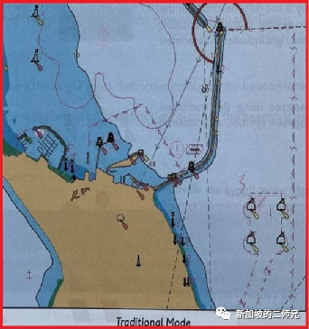
经典模式
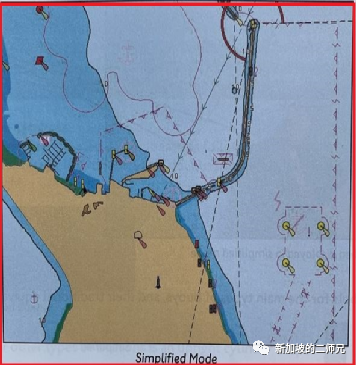
简化模式
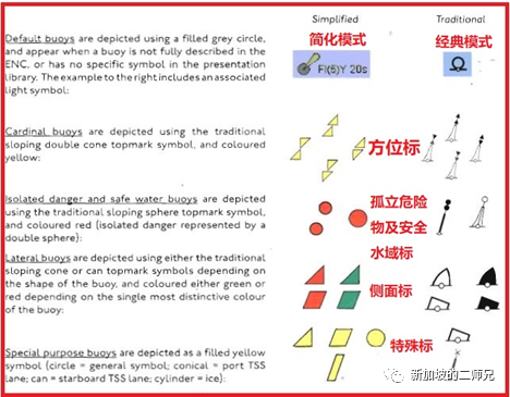
经典模式和简化模式的对比实例
6. New Symbols 新的图标
Some new symbols based on the features contained within the ENC data have been introduced to meet the specific requirements of ECDIS display
有一些新的图符引入用来显示一些航用图里的一些特征,所谓新的图标就我理解应该是相对于纸板海图来说的
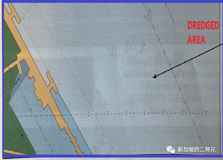
a.Dredged area 疏浚水域
Dredged areas are shown by a grey dotted area fill pattern, see below picture 疏浚水域会用灰色点充填格式显示,见下图
Depending on how the producer nation has captured the dredged area feature, the dredged / maintained depth value may not always display automatically. Where the value is not visible, the ECDIS pick report function can be used to view the value
疏浚水域的水深资料显示方式取决 于海图发行商的设计,有的设备不会直接显示水深资料,需要使用PICK REPORT工具来查看具体

b. Precautionary area/ prohibited area/caution area/ anchoring prohibited area
警戒区/禁入区/警示区/禁锚区
below symbols have individual features in ECDIS, and these symbols may appear in one of two sizes, smaller example depicts point application , larger example depicts area features where symbols will appear at the center of area depicted.
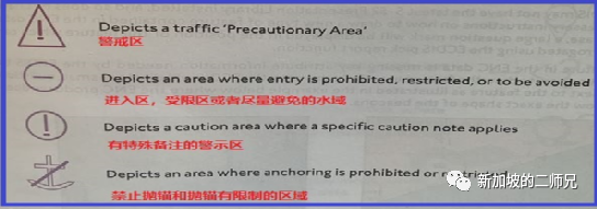
以下图标在电子海图中都有自己代表的特征,通常会显示为2种尺寸,小的图标是代表某点的特征,大的图标通常显示在适用的区域的中心代表整个区域的特征,如下图,这个锚地的图标和警戒区的图标是代表界限内的水域特征

In some area appear contradictory information, see below screenshot , means the anchorage is allowed to drop anchor with certain restriction, may only allowed small craft only, have to see pick report
有些水域会显示表面矛盾的图标,需要关注,如下图实际上代表着这个水域允许抛锚,但有一些限制,比如可能只允许小型船舶等等,需要和港方核实,在PICK REPORT里不一定有描述

7. Unknown Symbols 未知图标
Where the ECDIS encounters a feature in the ENC data that it is unable to determine how to display properly, it will default to displaying the symbols illustrated below with question marks(for point, line and area features respectively} either alongside, or in place of, the appropriate symbol.
当电子海图系统遇到系统数据不能确定如何正确显示图标的特征,那么就会显示成如下带有问号图示的标志,可能是一个点/一个区域或者一条线

There are a number of reasons why this symbol may appear. For example 有几种情况会导致这个标志显示在电子海图上,比如:
a)The ECDIS may not have the latest S-52 Presentation Library installed, and so does not have the necessary instructions on how to draw a new type of feature contained in the ENC data. In this case, a large question mark will be displayed in the position of the feature which can be interrogated using the ECDIS pick report function.
如果船上电子海图设别没有安装最新的S-52显示图库,就会导致某些数据不能正确显示出来,就有在这个数据附近打一个问号,可以通过打开PICK REPORT来查询
b) The feature in the ENC data is missing key attribute information needed by the ECDIS to determine how to draw the feature exactly. In this case, the ECDIS will display a small question mark next to the feature as illustrated in the example below where the ENC producer does not know the exact shape of the beacons. By interrogating the feature using the ECDIS pick report function it may be possible to identify which information is missing.
如果航用图数据丢失了关键的用于被电子海图系统识别特征的属性信息,也会显示问号,比如海图发行商不确定 某个灯桩的实际形状,同样可以打开PICK REPORT来查询具体信息见下图

c)The feature in the ENC data contains an unexpected, non-standard entry in one of the attributes associated with the feature. This may be the result of a data entry error by the ENC producer, but is more likely to be because the real world object does not conform to expected standards and feature categories. For example, a buoy may be painted in a colour that does not conform to its function (such as a lateral buoy painted yellow).
海图数据可能包含了一些非标准的数据输入,可能是海图发行商的错误输入,也可能是实际上某些物标的特征不符合标准,比如方位标标体颜色错误的涂成是黄色
Now list some examples for unknown symbols
下面具体列举几个未知图标

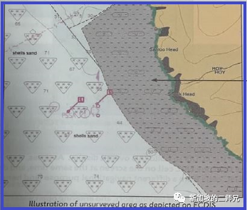
8. Un-surveyed areas and No data areas未经测绘的水域和没有海图数据的水域
a.Un-surveyed areas未经测绘的水域
ENC producers will display these areas on their charts where there is no survey data, or
where only basic survey data is available in complicated waters with many hazards to navigation, and which is therefore not adequate to support safe navigation.
如果某个海域没有测绘数据或者只有最基础的测绘数据,这个水域不能保障安全航行,这个时候海图发行商会把这个水域突出显示
See below screenshot, filled grey symbol with a dashed line pattern marking alphabet ”U” to indicate
如下图会使用灰色突出这个水域,并增加点划线填充,同时有字母U的标注
b. No data areas 没有海图数据的水域
When compiling the display, the ECDIS software will start by filling the screen with the default grey “no data” pattern. overwriting this grey display with the data that is installed in the ECDIS, giving first priority to the most appropriate scale ENC data that is available where there is no data available, or may have data but not of a suitable scale to display
当编辑显示时,电子海图软件会自动将没有数据的水域填充为灰色,来覆盖安装在电子海图系统里的数据,主要是为了显示最适合显示的相应比例尺的航用图数据,但可能这张航用图没有开通,或者已开通但当前比例尺不合适显示出来
如果船上没有开通某一水域的航用图ENC或者开通了这一水域,显示的比例尺不适合就会显示成左图的灰色区域
另外如果大洋中某张图的比例尺是1:3500000,船上已经有PERMIT,如果显示比例尺扩大到1:25000,如果继续显示数据不利航行安全,举个例子大洋中的沉船在最佳比例尺时和放大显示后的位置会发生很大变化,是不利航行安全的,为了安全这种情况会显示没有数据。

9. Magnetic Variation and anomaly 磁差及地磁异常
a.Magnetic Variation磁差变化
A new magenta arrow symbol is used to represent magnetic variation in positon or in an area, 通常会使用洋红色箭头来标识某个位置或某个区域的磁差,具体磁差和变化率需要打开PICK REPORT查看
b. Magnetic anomaly地磁异常
A hollowed out version of the magnetic variation symbol is used to indicate areas of local magnetic anomaly.
中空的磁差图标来标识这个水域有地磁异常存在
10. ECDIS display modes 电子海图系统显示模式
Total three display modes:
有3种显示模式:
1)Base’ Display”:This is the minimum level of information which has to be displayed at all times. It is not intended to be sufficient for safe navigation. Never be used in passage planning and implementation stage,
基础模式是显示最少的信息,也是在其他任何模式下一直显示的信息
在设计航线和航次执行中不可以使用该模式
2) Standard' display:may be considered to be the minimum information that must be displayed at all times, some important features such as soundings, submarine cables, and pipelines are not included in this display mode, and so must be switched on using the appropriate 'Custom' display settings available.
标准显示模式的信息要比基础模式多很多,是在任何时候(设计和执行计划)都应显示的,有些特征比如水深、海底电缆和管线等不在标准模式显示中,应在自定义中手动添加
3)Other: Displayed all the information available in the ENC data. The ECDIS display is
likely to be very cluttered when this mode is used, particularly if there is a lot of textual
descriptions or magenta information symbols on display. This tailoring of the display is
commonly referred to as 'Other' or 'Custom' display mode, depending on ECDIS type
其他模式:显示航用图的所有数据, 但是信息显示太多会显得很杂乱,尤其是是有很多的文字描述显示和洋红色的信息图标, 这种显示通常叫做其他模式或者自定义模式,取决于设备型号

基础模式
标准显示模式

其他模式
从上面的3张图可以清晰 的看出显示的差异,基础模式只显示岸线,岛屿,陆地等,没有额外的信息。其他模式显示的信息是最全的,当然也会显得有些杂乱
Display details and precaution 显示模式详解及须知
a.Data displayed for standard and other modes could be referred to left chart which derived from IMO performance standards,
标准模式和其他模式显示的数据如下图,可以看出其他模式相对于标准模式多了水深、海底电缆、磁差、等深线、潮汐、底质和其他等

b. It is strongly recommended that at some stage in the voyage planning process that 'Other’ display mode is used to visually inspect the intended route. Once a detailed voyage plan has been completed, it will be possible to reduce the Level of detail shown much closer to the 'Standard’ display so as to provide clarity of display during voyage monitoring, not recommended to display standard mode only without additional feature, particularly soundings
强烈建议在航线计划阶段使用“其他”显示模式来准备航次计划。一旦制定了详细的航行计划就可以将显示的详细程度降低到更接近“标准”显示,以便在航行监控期间过滤掉杂乱不重要的信息突出重要信息,不建议仅仅使用标准模式,而不添加额外信息,特别是水深信息
c. Feature objects which are not being displayed because of their selected ECDIS display mode settings, or are obscured from display by other detail, should still be detected by the ECDIS's alarm functions. However, mariners should not rely on automated alarms alone
因为显示模式的不同,有些物标特征没有在屏幕上显示,或者被其他信息遮挡并不会影响电子海图系统的预设报警功能,然而航海人员不应依赖于报警本身。
To be continus....
本文转自公众号 个人图书馆
更多信息请联系:
北京思拓海洋信息技术有限公司
北京市丰台区汽车博物馆东路 6 号院盈坤世纪大厦 F 座 405 室
电话:010 62680730
传真:010 62681683
邮箱:sales@enclive.cn
网址:www.enclive.cn