接上篇
10. ECDIS display modes 电子海图系统显示模式
LOOKAHEAD
Look ahead willcompare the safety settings that have been enteredin ECDIS and generatesan indication or warning where the safety settings will be breached Look ahead 。
主要的功能是对比事先设定在电子海图的安全参数,然后在可能要违背安全设定的情况下激发警报。
请注意:
在我司的电子海图NAVMASTER中这个LOOK AHEAD 功能是通过GUARD ZONE 来实现的,本身NAVMASTER也有LOOK AHEAD 菜单,但没有执行IMO和IHO的要求的功能,在外部检查时,如果检察官问LOOK AHEAD的操作,请演示GUAND ZONE而不是LOOK AHEAD。
IMO 对 LOOK AHEAD的功能要求如下:
·ECDIS shall give an alarm if, within a specified look-ahead time or distance set by the mariner, own ship will cross the safety contour。
电子海图应具备在船位将穿越安全等深线之前的预设距离或时间内发出警报
·ECDIS shall give a warning or caution, as selected by the mariner, if, within a specified look-ahead time or distance set by the mariner, own ship will cross the boundary of a prohibited area or of a geographic area for which special conditions exist。
同样在穿越禁航区或者有特殊要求的水域前也要能够发出警报或提醒
·A caution shall be given to the mariner if, continuing on its present course and speed, over a specified look-ahead time or distance set by the mariner, own ship will pass closer than a user-specified distance from a danger (for example obstruction, wreck, rock) that is shallower than the mariner's safety contour or an aid to navigation
同样在有可能近距离通过危险区域,比如障碍物、沉船、礁石,并且水深小于安全等深线, 也要有警示信息′Caution: Never switch off Look Ahead function, except in exceptional circumstances where the alarms become distracting dangerously′。
注意:
不要关闭LOOKAHEAD功能,除非是在特殊情况下报警会严重分散或干扰驾驶员的注意力
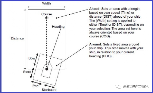
Normally LOOK AHEAD sets the area ahead and around own ship for which to check for safe navigation. See below picture:
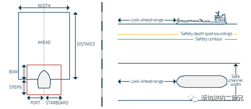
通常LOOKAHEAD是设定本船船首方向以及本船周围的一部分水域来进行检查保证安全航行
Example 1:
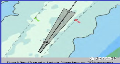
Guard zone( look ahead function)indication in NavmasterECDIS, if safety contour / prohibited area /obstruction/ wreck enter the zone,alarm (warningor caution)will trigger
上图是我司NAVMASTER电子海图设备显示的LOOKAHEAD 设定,如果进入上个SLIDE里提到的危险水域就会报警或者警示信息

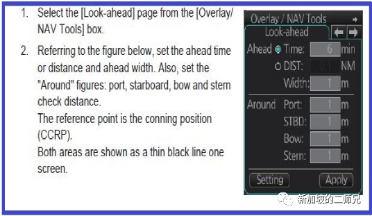
In above screenshot you will see how to set look ahead in Navmaster ECDIS, actually route monitoring alerts+ guard zone will be complete look ahead function.
在上图所示,我们可以看到如何在NAVMASTER里设定LOOK AHEAD,实际上在这个设备里航线监控报警加上警戒区才是一个完整的LOOK AHEAD功能
Example 2
Below pictures is how to set look ahead in Furuno ECDIS, you can easily find out the setting in Furuno is more similar with the original requirement of Look ahead function.
如上图所示,如何在FURUNO电子海图上设置LOOK AHEAD, 可以看出这里的设定方式会更接近LOOK AHEAD的公约要求.
11. T &P notice correction 临告和预告改正
The AIO is designed to display temporary and preliminary information over ENCs in ECDIS to assist with passage planning.
AIO 其实就是用于在电子海图系统显示临告和预告信息,协助航行计划.
Most countries now include temporary information in their ENCs and it is received on the vessel as a normal ENC update or new edition. Some nations do not describe the information as 'temporary’ or 'preliminary’ in the ENCs; they simply issue updates as required
大部分国家都会在航用图中发布临告和预告信息,船舶每周都会收到和永久性改正一样更新包, 其中有一些国家会直接在图上改正,就不额外显示临告预告信息
Some nation providing additional information that is not already included in the ENC will be displayed using coloured polygons within AIO.
有些国家不会把临告预告直接改正在海图中,就会在海图上显示一个多边形(通常四边形)带有颜色的区域表明这个位置有临告预告,需要手动改正
UKHO will publish a notice on the status of of T&P information in ENCs on regular basis, last publish on Mar 2021, and clearly stated which countries will include T&P information in ENC,
英国水道测量局定期会发布一个关于临告预告改正的指南“Status of T&P information in ENCs”,上一次是在今年3月份发布的,里面明确说明那些国家发布的航用图会把临告预告并入海图中,不需要额外改正,这个通告在海务通函02/2021可以查看,如下面通告截图:

可以清楚的看到中国发布的ENC就不会直接改正临告预告,需要手动改正航线附近的通告,如果是德国发布的ENC就会直接改正,不需手动改正
From above screen shot you can see for those country marked T and P as YES, there is not necessary to correct manually, otherwise manual correction on T&P notice required for the area close to route
需要提醒的是,如果手动改正了T&P, 当通告过期时不要忘记删除MANUAL UPDATE, 要有记录本记录哪张图进行了哪些通告的改正,和纸板通告的管理是一样的
Just be reminded that if manual update T&P notice on ECDIS, do not forgot to delete after cancelling the notice, record should be in place which chart and which notice are corrected
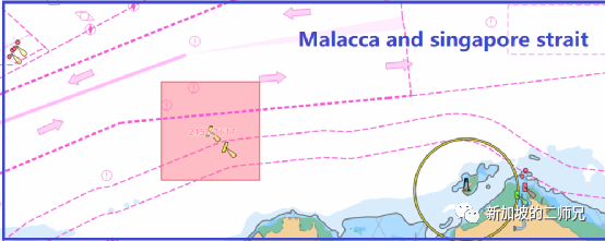
Make another example, as below picture shown 2152(T)/17 was valid temporary notice for the Malacca and Singapore strait waters, as per the UKHO notice, T and P notice will not be included in ENC in this water, manual correction will be needed, you should use “manual update function to do this correction
如下图,新加坡马六甲海峡在英国水道测量局的通告中就属于没有把临告预告包括在ENC里的,所有要进行手动改正,通常使用MANUAL UPDATE 功能键
12. EP notice correction 临告和预告改正
ENC Preliminary (EP) NMs highlight navigationally significant differences between ENCs and ADMIRALTY paper charts,it will not automatically corrected in ECDIS
电子海图中的EP通告其实是显示出电子海图和纸板海图通告的差异,这种通告并不会直接改正在电子海图上,需要参考相应的纸板海图通告进行手动更改
13. Track recall 调取航迹
In previous,voyage recording I had explained IMO requirement for past voyage data recording and track recall, here I will not state further, I would like to explain the procedure for recalling track for NAVMASTER ECDIS
在公总号第一篇电子海图的航行记录里有明确说明船上应具备存取相关航迹的要求,再次不具体描述,本页来解释下如何调取航迹,针对船队的NAVMASTER 电子海图设备
Remember that normally you will be able to recall the whole voyage track in one log, but due to some reason, you may need to open multiple log to show the whole route track, maximum days of indicating track without recall is 72 hour(3 days)
正常情况下船上应该可以在一个LOG里调取整个航次的航迹,实际工作中由于某些原因需要开启多了LOG才能把整个航次的航迹调取出来,在外部检查中可能会比较被动,需要驾驶员了解本船的实际情况,做好应对和解释
As below picture shown, normally positions shown could be set maximum 72 hour, and track indicating the same duration, recommended to set 72hour,
如下图所示,在显示船位航迹设定时,通常要选取最大的时长72小时

注意 Attention:
In Navmaster ECDIS if ECDIS does not be closed accidentally the log will remain one log, otherwise multiple logs will be occurred, it is not convenient to present to inspector, the basic rule is one voyage open one log( one port to another port )
在NAVMASTER电子海图中如果软件没有意外关闭通常LOG不会关闭新建新的LOG, 如果系统意外关闭,再开启就会自动建立新的LOG,这样在外部检查实际是是不利的,容易被开缺陷,基本的原则是一个航次只开一个LOG,或者一个港到下一个港也可以
14. Scamin
Scamin is an abbreviation of Scale Minimum, The SCAMIN value of an object determines the display scale below which the object is no longer visible on ECDIS. The purpose of SCAMIN is to reduce the amount of clutter displayed to the ECDIS user.
SCAMIN是最小比例尺的意思,主要指的是当海图比例尺小于设定的比例尺,某些图标或特征就不再显示在海图上,从而减小使用者看到的过多信息,影响安全航行
For example, an object with a SCAMIN value of 50,000, indicating a scale of 1/50,000, will not be shown on a display of 1/60,000
举个例子如果一个物标的SCAMIN设定的比例尺是1/50000, 那么在比例尺1/60000时就会显示了
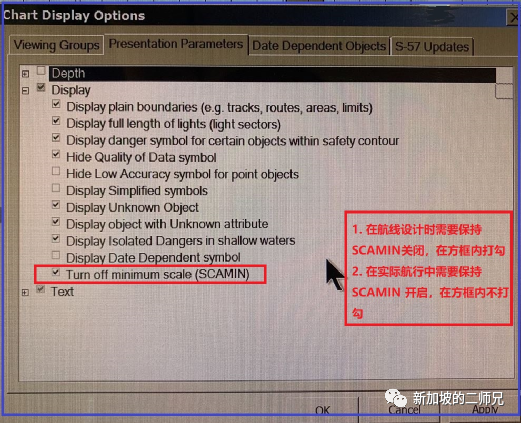
During the passage planning stage, we do not want to miss any of the features or buoy, etc as we do not want to have our courses run over these.
在航线设计的阶段, 我们不希望忽略掉一些重要信息比如浮筒等,防止实际航行中进入危险区域
During navigation, we can keep the SCAMIN to “on” to declutter the ECDIS screen
在实际航行中,为了过滤掉过多信息,建议保持开启
In some ECDIS model, may have Scamin/Scamax setting
在某些电子海图设备中,可能会有最大和最小显示比例尺的选择。此处大家要理解清楚,什么时候勾选什么时候不勾选,不要搞混了,在外部检查时是必查项目,驾驶员都要熟悉
15. Replay voyage data (VDR Playback)

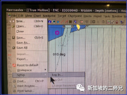
Normally this function only be conducted at Admin user account, after logging in, go to tool menu, select playback.
目前我司的NAVMASTER 电子海图设备需要在管理员账号下进入菜单进行测试
16. Position Verification means and interval 船位核对方式和间隔
( for ships which ECDIS as primary means of navigation)
电子海图为主要航行方式的船舶
a.Basically speaking, considering the position in ECDIS can be seen in real time, we should stop talking position fixing, it should be called position verification since the position of vessel is well known (position already appeared on ECDIS screen)
通常来说,考虑到电子海图上的船位已经实时显示,以前我们纸版海图中说的定位应该改为核对船位
b.But The bridge team should avoid becoming over-reliant on ECDIS. Regular cross-checks should be carried out to verify the accuracy of ECDIS position-fixing system (normally GPS) by other available means:
但是驾驶台班组应该避免过度依赖电子海图,包括实时显示的GPS船位,仍然需要通过以下多种方式和途径来核对电子定位系统的船位精度:
·Parallel indexing and use of clearing bearing 平行线和方位避险线
·Radar range and bearing 雷达距离和方位
·Visual cross bearings 目视方位
·Regular check on signal to noise ratio of the GPS system in use
定期的检查GPS系统的噪音比例信号
·Plotting positions on the ECDIS using electronic LOP from visual/radar bearing and ranges to compare the position from GPS.
使用LOP工具以目视、雷达方位距离来定位的方式核对GPS的船位
·Radar overlay 雷达叠加信号
·Celestial observation 天体观测
·Other means 其他方式
目前按照公司的体系要求,开敞水域每小时核对船位,沿岸水域和港口水域每20分钟核对船位,如果电子海图系统失效,使用备用系统电子海图的话,按照公司体系的要求SQI-122进行定位
Currently as per company requirement, in open water verify position every hour, in coastal / port water every 20min verify position, if ECDIS failure, paper chart as back up system, the position fixing means and interval requirement in company procedure SQI-122 should be complied。
17. CATZOC 海图精度
Category Zone of Confidence (CATZOC) are the values that used to highlight the accuracy of data presented on charts。
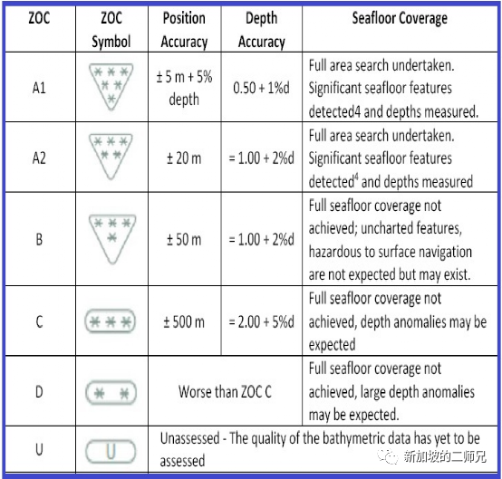
·Based upon the error in position and depth, the accuracy data is divided into 6 zones of confidence (CATZOC). See above picture
基于位置和水深的精度CATZOC 分为6个等级,如上图
·So we have to understand the CATZOC not only referring to depth, but also to position, so while passage planning, CATZOC should applied to UKC calculation, and CATZOC position accuracy should applied to dangerous objects clearance, such as wreck, shallow waters, obstruction, etc
我们必须清楚CATZOC不仅涉及到水深精度,同时也包括位置精度,所有在计算UKC富裕水深的时候要考虑CATZOC, 在航线设计阶段决定危险物的距离时也要考虑在内,比如距离沉船,浅水区域,障碍物等
·After applying CATZOC calculation into UKC, the result should comply with company UKC policy.
在考虑海图精度后计算的富裕水深要符合公司UKC 政策
·After taking position accuracy into account ship should have sufficient clearance from danger, and for ZOC D and U accuracy, we should follow below:
在考虑位置精度后船舶要保持与危险物有足够的安全距离,当精度是D 或者U 的时候应遵循以下原则:
a.minimum keep 10 nm from danger for open water
开敞水域保持至少10海里
a.Minimum keep 5nm from danger for coastal water
沿岸水域保持至少5海里
18. CATZOC D and U
If vessel can’t keep clear from CATZOC D/U waters, as per company procedure following action need to be taken:
如果船舶航行水域不能避开海图精度为D和U 的水域,根据公司程序以下措施应采取:
a. For UKC greater than 50% of ship’s static draft 对UKC大于船舶静态吃水的50%
·Keep Echo Sounder on 保持测深仪开启
·Monitor UKC Continuously 保持持续监控UKC
b. For UKC less than 50% of ship’s static draft对UKC小于船舶静态吃水的50%
Risk assessment need to be conducted and seek approval from head office for transiting this water。需要实施风险评估,并由公司批复。
All control measures and factors to be considered had been stated in company procedure SQI-140 which mentioned in next page should comply
体系规定的控制措施和需要考虑的因素需要遵循,请见下图具体要求
Below picture showed CATZOC all categories covering percentage in the world water, just for reference。下面的图片列举了全球水域海图精度的分布比例

Company requirement on CATZOC U and D (UKC<50% draft)
公司体系关于精度U和D的措施要求
Consideration should be given to the possible applicability of the below given controls in reaching such a decision: 应考虑一下因素:
·Up-to-date Navigational Charts Scale for the inland / port waters, if in open water take home chart should be referred, if in coastal water office may obtain paper chart information from contracted paper chart supplier
是否有纸版海图,可以跟协议供应商申请或索取扫描版:
·Other relevant Nautical Publications 其他航海图书
·Caution Notes such as (Navarea messages, Navtex warnings, etc.)
航行警告和大区航警
·Bottom quality / nature of the sea bottom 底质
·State of the water (calm or rough) 海况
·Control of transit speed (to minimise squat) 通过速度
·Accuracy of the ship’s draught 吃水精度
·Channel transit during high water 是否可以高潮时经过
·Manoeuvrability of the vessel 船舶自身操纵性
·Any other operational constraints that may be applicable due to vessel’s UKC
因为UKC的要求,其他的操作限制可能会申请
·General and expected movement of traf?c in the area. 船舶交通流
Additional measures could include information obtained by Local Authorities such as the Harbour Master, Port Agent and Pilot regarding:还可以采取额外的措施,包括向港方、代理及引航站获取必要的信息:
·Date of the most recent dredging 最近航道疏浚的日期
·Maximum allowed arrival/departure draft 允许的最大抵离港吃水
·Most recent deepest arrival / departure draft (arrival and safe berthing of vessels of similar size and draft establishes a degree of safety for the transit under pre-vailing environmental conditions) 同类型船舶近期通过的情况
·Latest sounding report 最近的测绘报告
Please note this is not an exhaustive list and other information may be requested.
When the pilot boards the vessel, the Master should present the passage plan to the pilot along with the UKC calculation of the transit. The Master should bring to the attention of the pilot the parts of the transit through shallow waters and discuss in detail the following points:
当引水登轮要和引水精确计算UKC 和低精度水域的通过计划,并包括以下方面:
·the ship’s dynamic UKC 船舶的动态富裕水深
·the uncertainties derived by the ZOC category of the Navigational chart covering the transit. 水深精度带来的不确定性
19. Expired chart permit management
It is highly recommended that once the permit expires the ENCs should be manually deleted. It would reduce the chances of using outdated ENCs.
目前体系没有要求,这里强烈建议一旦海图许可过期过,立即删除相应的ENC许可,否则过期的海图可能被误用,危及航行安全
请注意:
过期的海图单元在海图每周更新时并不会安装海图更新
Be noted that expired ENC cell will not subject to weekly update.
20 .Cyber precaution while updating ENC
更新电子海图时的网络安全考量

for single ECDIS ships: handover notes for updating should pass to officer took over the watch in order to remind reliever to monitor furtherly
对单套电子海图的船舶来说,更新电子海图后要交代给接班驾驶员保持关注工况
for dual ECDIS ships: Update one ECDIS first, and handover notes for updating should pass to officer took over the watch,only after at least 12 hours later update the secondary ECDIS.
对安装双套电子海图的船舶来说,首先更新一台电子海图,然后接班驾驶员要保持监控实际工况,至少间隔12小时以上再更新另一台电子海图,并通知相关值班驾驶员的海图更新状态
21. ECDIS failure 电子海图失效

See above flowchart, actions to be taken in case of ECDIS failure had been clearly stated
如上图,电子海图失效包括双套电子海图失效的措施已说明的很清楚
Basically following steps should be follow:
·The 'Officer of the Navigational Watch (OOW) shall immediately call the Master and inform the Engine Officer on duty 驾驶员立即通知船长和机舱
·Put M/Engines on notice and reduce speed 备车降速
·Refer to available paper chart, plot vessel's position 参照纸版海图,定位
·Activate Radar Maps if available 激活雷达海图
·Carry out Navigational Risk Assessment and contact office to decide next course of action.实施风险评估,联系公司请求协助
·Contact with equipment manufacturer and service provider to solve the problem联系设备厂家和服务公司问题解决
本文转自公众号 个人图书馆
更多信息请联系:
北京思拓海洋信息技术有限公司
北京市丰台区汽车博物馆东路 6 号院盈坤世纪大厦 F 座 512 室
电话:010 62680730
传真:010 62681683
邮箱:sales@enclive.cn
网址:www.enclive.cn